1 BCE (2000 years ago) Roman trade in India through Sopara & Kalyan ports, Naneghat pass and then to Junnar, Nasik & Paithan in today's Maharashtra - Part 1
Minor update on 22nd Dec. 2022
For second and final part, please visit https://ravisiyermisc.blogspot.com/2022/07/1-bce-2000-years-ago-roman-trade-in_27.html .
I am very interested in this history as Sopara & Kalyan are close to Mumbai & Dombivli, and I have lived for many years in Mumbai (Bandra & Andheri suburbs) & Dombivli (till 2002). 1 BCE is over 2000 years old!
I don't think while I was living in Mumbai & Dombivli, I knew about Roman trade 2000 years ago through Sopara & Kalyan ports, as otherwise I would surely have visited whatever remains are there, of these port areas in today's Nalla Sopara and Kalyan town/city. Note that I have been to Kalyan town/city many, many times in the past (till 2002).
Some years ago (after 2002), as I started reading up on history in general, and Indian history in particular using Internet sources mainly but also some history books, I came to know of Roman trade through Sopara port (and I think I may have read references to lesser trade through Kalyan port). But I did not know the details. Over past few days, I had the pleasure of digging up and finding out about these details. I felt some readers may be interested in these findings and so am putting up this post.
This post will not cover the Naneghat 2nd to 1st BCE inscriptions as they are covered in my earlier post: Oldest inscriptions referring to Hindu deities, in this case, Samkarshana and Vāsudeva (Balarama and Krishna) in 2nd/1st century BCE, https://ravisiyer.blogspot.com/2022/07/oldest-inscriptions-referring-to-hindu.html .
Given below are relevant extracts from Indo-Roman trade relations, https://en.wikipedia.org/wiki/Indo-Roman_trade_relations :
Indo-Roman trade relations (see also the spice trade and incense road) was trade between the Indian subcontinent and the Roman Empire in Europe and the Mediterranean Sea. Trade through the overland caravan routes via Asia Minor and the Middle East, though at a relative trickle compared to later times, preceded the southern trade route via the Red Sea which started around the beginning of the Common Era (CE) following the reign of Augustus and his conquest of Egypt in 30 BCE.[1]
The southern route so helped enhance trade between the ancient Roman Empire and the Indian subcontinent, that Roman politicians and historians are on record decrying the loss of silver and gold to buy silk to pamper Roman wives, and the southern route grew to eclipse and then totally supplant the overland trade route.[2] Roman and Greek traders frequented the Indian subcontinent, present day Southern India and Sri Lanka, securing trade with the seafaring Tamil states of the Pandyan, Chola and Chera dynasties and establishing trading settlements which secured trade with the Indian subcontinent by the Greco-Roman world since the time of the Ptolemaic dynasty[3] a few decades before the start of the Common Era and remained long after the fall of the Western Roman Empire.[4]
...
In the 1st-century CE Periplus of the Erythraean Sea, its anonymous Greek-speaking author, a merchant of Roman Egypt, provides such vivid accounts of trade cities in Arabia and India, including travel times from rivers and towns, where to drop anchor, the locations of royal courts, lifestyles of the locals and goods found in their markets, and favorable times of year to sail from Egypt to these places in order to catch the monsoon winds, that it is clear he visited many of these locations.[9]
[References:]
1. Shaw 2003: 426
2. Young 2001: 19
3. Lindsay 2006: 101
4. Curtin 1984: 100
9. William H. Schoff (2004) [1912]. Lance Jenott (ed.). ""The Periplus of the Erythraean Sea: Travel and Trade in the Indian Ocean by a Merchant of the First Century" in The Voyage around the Erythraean Sea". Depts.washington.edu. University of Washington. Retrieved 19 September 2016
--- end wiki extracts ---
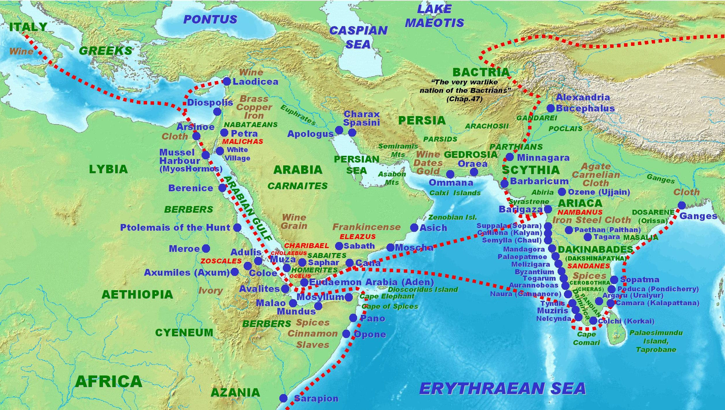
This map from above wiki page seems to be derived from the above mentioned 1st CE work/document/book: Roman trade in the subcontinent according to the Periplus Maris Erythraei 1st century CE, https://upload.wikimedia.org/wikipedia/commons/1/1b/Indo-Roman_trade.jpg . Sopara and Kalyan are mentioned in this map, dated to around 2000 years ago! Further, many ports in India's West coast are shown, and the wiki page mentions lot of Roman trade with South India via Southern ports on India's West coast. The map is reproduced below:
[On PC desktop, to open pic in larger resolution (if available), right-click on pic followed by open link (NOT image) in new tab/window. In new tab/window you may have to click on pic to zoom in.]
The following link is of a pic from above wiki page: Roman gold coins excavated in Pudukottai, Tamil Nadu, India. One coin of Caligula (37–41 CE), and two coins of Nero (54–68). British Museum., https://upload.wikimedia.org/wikipedia/commons/5/58/Roman_gold_coins_excavated_in_Pudukottai_India_one_coin_of_Caligula_31_41_and_two_coins_of_Nero_54_68.jpg .
Fascinating that coins of Caligula and Nero Roman emperors were found in Tamil Nadu, India! Awesome testimony to Indo-Roman trade of the past!
In this post, I am focusing only on Indo-Roman trade via Sopara and Kalyan ports through Naneghat pass to towns/cities of Junnar, Nasik, Paithan and others in interior areas of today's Maharashtra state.
Given below are few extracts from page 30 & 31 of the book Indo-Roman trade by Singh, Ajoy Kumar, https://archive.org/details/in.ernet.dli.2015.131452 :
Sopara, ancient Suppara, was an important market town during the opening centuries of our era. It was situated a few miles north of Bombay. It is said to have been the capital of Konkan. The Periplus takes it as a market town of the region which in the time of the elder Saraganus became a lawful market town. It is referred to in many ancient and medieval sources— Sanakrit, Pali, Greek and Latin. All these sources are unanimous on the point that it was a great city and a great port. This place had an intimate connection with the interior of the country and was connected with Paithana via Kalyan.
Kalyan was another important port town of ancient India. It has been called the ancient gate-way of India because of its location and importance. It is situated on the southern bank of the river Ulhas, twenty-two miles from the open sea, but it does not empty itself directly into the sea. The river is seen to be fed by two main streams that led to three different passes:
(a) The Thal Pass . — Through it the ancient Nasik could be reached which was located on the river Godavari.
(b) The Bhor Pass . — -Through this one could go to Poona located on the banks of the rivers Bhima and Krishana.
(c) It led to the Nana Pass and through it the ancient city of Junnar could be approached and from there one could go to Paithan. Kalyan is mentioned in thirteen inscriptions; eleven of such inscriptions are found at Kanheri Buddha Cave inscription and the remaining two at Junnar. The route from Kalyan via the Nana pass is definitely established by an inscription at Kanheri which links Sopara, Kalyan and Paithana.
According to the Periplus Kalyan was a city. By listing the city of Kalyan among the coastal marts of the Deccan and by referring to ships sailing in and out of the place, the Periplus tells us implicitly that Kalyan was both a city and a harbour. Cosmos (bk-. XI) also refers to this port town and high-lights its significance. It has been called Calliena by the Periplus and Kalliana by Cosmos. It was the principal port of the Satavahana Kingdom during the period when it held the west coast. It was a celebrated and much frequented emporium. During the early rule of the Satvahanas Kalyan grew into an International trading centre. The Periplus supplies us with a list of exports and imports of Kalyan while it was open to international trade. But during second century A.D. the importance of Kalyan decreased and it virtually declined for Ptolemy does not make any mention of it though Barygaza and Symlla (Chaula) found their place in his geography. But from 5th century A.D. it regained its lost importance and the Alexandrian merchant Cosmas Indicopleustes refers to this place while describing Christianity in his classics Topography. According to him, “The best known trade centres of India are these : Sindon, Orrhota, Kalliana, Sibor, the Male (country), which has fine centres exporting pepper; Parti, Mangorouth, Solapatna, Nalopatana, Pudopatana”.
--- end book extracts ---
Now let us see some pics of Google Map to see the waterway from the coast to Kalyan.
First let us see Sopara (which is the ancient town near today's Nalla Sopara). The Google Map screenshot below shows Nala Sopara in top right. The coast is close to it. You can also see a waterway going inland from below Nala Sopara labelled Vasai creek.

The Google Map screenshot below shows the waterway from the coast - labelled Vasai creek and in blue colour - go towards Thane and then Dombivli and Kalyan. Also note that from Kalyan a yellow line goes to the right to Murbad and the road is labelled 61.

The Google Map screenshot below, map link: https://goo.gl/maps/W256zmSMwAwkVTYm7 , zooms in on the waterway in its path from Thane to Kalyan. Note that the waterway splits into two near Thane with a thinner waterway (Thane creek) going towards the bottom of the map and the larger waterway going towards Mumbra and then Dombivli and Kalyan with the label being Ulhas river. Actually it is Ulhas river that flows downstream towards the sea coast but splits into two creeks near Thane, one being Thane creek and other being Vasai creek.

The pic below is a satellite version of above map.

Now I commuted from Dombivli to Mumbai by local train for perhaps 15 years or so (from 1980 to 2002 with some gaps). The stretch from Dombivli to Diva (or reverse), after going past the buildings near the stations, was (and still is, going by some youtube videos I saw recently) very picturesque with lots of greenery and on one side, stretches of a water body which some referred to as khaadi (खाडी) in Marathi meaning creek. I now understand that from an accuracy point of view, it is the Ulhas river which as it gets closer to the coast, as mentioned above, splits into Vasai creek and Thane creek.
Over past few days, I saw few videos showing the rail journey from Thane to Kalyan, about Ulhas river in this area. I felt an urge to share a lot of details from these videos, due to my Dombivli association in the past. I seek the kind indulgence of readers for these details I have shared below.
At 3 min. 25 secs. in following video, we have a great aerial (drone?) shot of the Ulhas river coming from the top of pic and going to left of pic with a smaller waterbody called Desai creek joining it from the top right. A new railway track was laid and made operational recently. During my Mumbai/Dombivli days, this track was not there and from a train on the old track one could not see what is shown in pic below.
Thane Diva New 5th-6th Rail lines Started after long time, https://www.youtube.com/watch?v=Ip3buOcSLws , 4 min. 19 secs, published on 19th Feb. 2022 by Droneman. Screenshot from this video:

The following video from 30 secs. to 1 min. 20 secs. shows the Ulhas river from the new railway track and around the 1 min 15 secs. point the video shows Ulhas river coming downstream from the left top of video with the railway track continuing on the right alongside the Desai Khaadi (the captions in the video do not mention Ulhas river but refer to the whole water body as a creek, which I think is a mistake): New 2022 [ Kalwa-Diva Jn.] Local Train Line | Beautiful Creek Bridge, https://www.youtube.com/watch?v=Y0pMDcwYVKE , 8 min. 38 secs, published on 7th Jan. 2022 by adityakambli6495.
The screenshot below is showing bridges NOT over Ulhas river but over Desai creek (Khaadi) just after Mumbra Railway station going towards Diva. It is from this interesting video published by Indian Prime Minister Narendra Modi's YouTube account: Thane-Diva new railway lines: Ensuring fast connectivity, enhancing ease of living, https://www.youtube.com/watch?v=EpFGwJPP-mM , published by Narendra Modi on 18th Feb. 2022:

From around 8 mins. 55 secs. to 12 min. 45 secs. of following video, we have the Mumbra to Dombivli part of the journey. Thane to Kalyan complete train journey || 17617 cmst-nanded Tapovan exp, https://www.youtube.com/watch?v=ErZw-XBzPuU , around 20 mins, published on 8th March 2022 by Sumant MH 30. The initial creek bridge is over a small creek that is connected to Ulhas river. Later at 10:40 we get a glimpse of the Ulhas river on top left of screen. Then from 11:07 to 11:25, we clearly see Ulhas river on the left of the screen. Given below are a couple of screenshots of Ulhas river as seen from the train in above video:


There is also a rail link from Panvel to Vasai that goes near Dombivli and this rail link has a bridge over Ulhas river in Dombivli (West) area. I have not been on this rail link nor gone to the Dombivli (West) area from where this bridge can be seen. Fortunately, there are two good youtube videos on it, which are given below:
*) Saat Pool Dombivli, https://www.youtube.com/watch?v=prSVV58FyUs , 27 secs., published on 29th Dec. 2017 by M A. Screenshot below is from this video.

*) Train Passing Ulhas River Bridge | सातपुल | Diva - Vasai Line., https://www.youtube.com/watch?v=NbOGoMgSSDU , 1 min. 10 secs., published on 24th Nov. 2019 by Karthik Iyer. Screenshots below are from this video:


I searched on the Internet for ancient Kalyan port ruins but did not get suitable results. Then I looked for a video about Ulhas river in Kalyan. The following video in its initial seconds itself shows a picture of the Ulhas river at Kalyan with a road bridge over the river.
DURGADI BRIDGE KALYAN 4K DRONE VIDEO, https://www.youtube.com/watch?v=URHvLcmdr2o , 2 min. 39 secs. published on 19th Sept. 2021 by Dronevala_somesh. Screenshot below is from this video:

So now we have a good idea of how boats from the Western seacoast of India like Sopara port, could carry goods inland to/from Kalyan in 1 BCE which is over two thousand years back. This enabled Indo-Roman trade from Rome & Egypt with interior parts of Maharashtra like Paithan, Junnar and Nasik going back two thousand years!
In the next and final post, I will cover the Kalyan to Naneghat pass journey on land, after which the route is on the Deccan plateau and would have been relatively straight forward from then on, to Junnar, Paithan and Nasik, two thousand years ago. [Please excuse my repeating the "two thousand years ago" phrase in past few sentences. But I felt I should do it so that readers don't miss out on the ancient aspect of this Indo-Roman trade route.]
[I thank Wikipedia, Singh, Ajoy Kumar (author of Indo-Roman trade) and archive.org, Google Maps and various YouTube video authors/publishers whose videos are mentioned above, and have presumed that they will not have any objections to me sharing the above extract(s)/screenshots from their website/Maps/videos on this post which is freely viewable by all, and does not have any financial profit motive whatsoever.]
Comments
Post a Comment